


Farming & Agri-Tech: Drones for Crop Monitoring and Analysis
Explore how advanced drone technology revolutionizes agriculture through precision crop monitoring, resource optimization, and data-driven decision-making. Discover the latest applications, benefits, and future trends in agricultural drone systems.
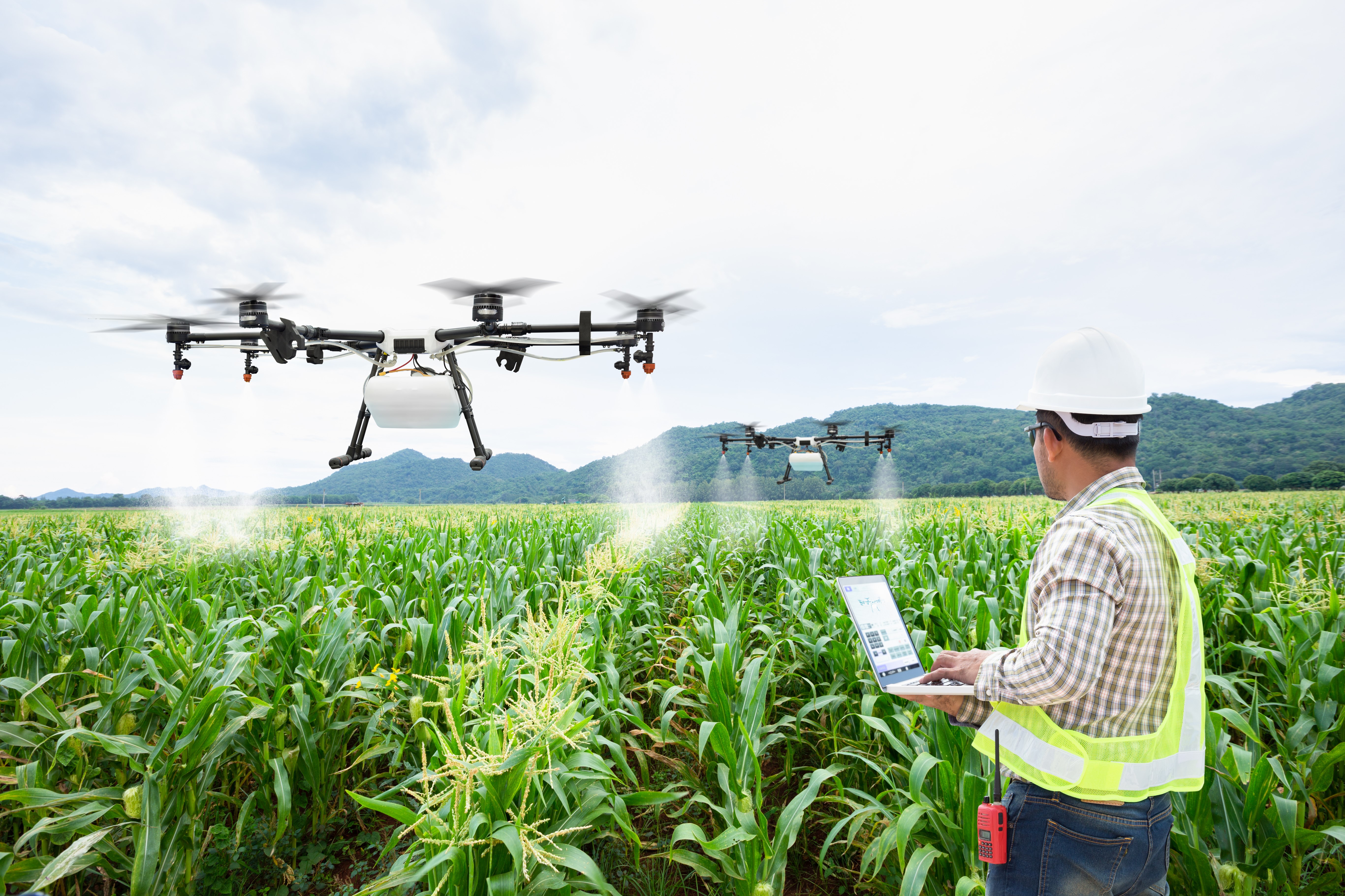
In the rapidly evolving landscape of agriculture, farming has transcended traditional practices to embrace cutting-edge technologies. Among these innovations, agri-tech has emerged as a transformative force, revolutionizing how farmers approach cultivation, resource management, and yield optimization. At the forefront of this technological revolution are drones , which have redefined crop monitoring and analysis by offering unparalleled precision and efficiency. These unmanned aerial vehicles (UAVs) are not just tools but catalysts for change, enabling farmers to adopt data-driven strategies that enhance productivity while minimizing environmental impact.
The integration of drones into farming operations is reshaping the agricultural ecosystem. By leveraging advanced sensors, imaging technologies, and real-time data analytics, drones provide actionable insights that were previously inaccessible. From detecting early signs of pest infestations to assessing soil health and optimizing irrigation systems, drones empower farmers to make informed decisions that directly impact crop quality and yield. This article delves into the multifaceted role of drones in modern agriculture, exploring their applications, benefits, and the future potential they hold for sustainable farming practices.
As we navigate the complexities of global food security, climate change, and resource scarcity, the adoption of drone technology in agriculture becomes increasingly critical. Farmers worldwide are recognizing the value of drones as indispensable tools for achieving operational excellence and sustainability. This comprehensive guide will explore how drones are transforming crop monitoring and analysis , providing a detailed roadmap for integrating this technology into farming practices. By understanding the capabilities and advantages of drones, stakeholders in the agricultural sector can harness their full potential to drive innovation and growth.
Understanding Drone Technology in Agriculture
To fully appreciate the transformative role of drones in agriculture, it is essential to delve into the intricate components and functionalities that define drone technology . At its core, an agricultural drone is an advanced piece of machinery designed to capture, process, and analyze data with remarkable accuracy. The fundamental architecture of these UAVs comprises several key elements, each contributing to their effectiveness in crop monitoring and analysis .
Core Components of Agricultural Drones
The primary structure of agricultural drones includes a lightweight yet durable frame, typically constructed from carbon fiber or high-grade polymers. This design ensures optimal flight stability while maintaining portability for ease of use in diverse farming environments. Equipped with powerful propulsion systems, drones can cover vast expanses of farmland efficiently, often spanning hundreds of acres in a single flight. Advanced battery technologies, such as lithium-polymer cells, provide extended operational durations, enabling comprehensive data collection without frequent interruptions.
Central to the functionality of agricultural drones are their sophisticated sensor arrays. These sensors include multispectral, hyperspectral, and thermal imaging cameras, each serving a distinct purpose in crop analysis . Multispectral sensors capture light across various wavelengths, allowing farmers to assess plant health through vegetation indices like NDVI (Normalized Difference Vegetation Index). Hyperspectral imaging provides even more granular data, identifying specific stressors affecting crops at the molecular level. Thermal sensors measure temperature variations across fields, helping detect issues such as water stress or equipment malfunctions.
Data Processing and Integration Capabilities
Modern agricultural drones are equipped with onboard processing units capable of handling complex computational tasks in real-time. These processors utilize artificial intelligence algorithms to analyze sensor data immediately after capture, generating preliminary insights before the drone returns to base. This capability significantly reduces the time between data acquisition and actionable decision-making. Furthermore, most drones are designed to integrate seamlessly with existing farm management software systems, facilitating smooth data transfer and comprehensive analysis.
The integration extends beyond hardware to encompass robust connectivity features. Many agricultural drones support multiple communication protocols, including Wi-Fi, Bluetooth, and cellular networks, ensuring reliable data transmission even in remote farming locations. Some advanced models incorporate GPS and RTK (Real-Time Kinematic) positioning systems, achieving centimeter-level accuracy in geospatial data collection. This precision enables precise mapping of field conditions and facilitates targeted interventions in specific areas requiring attention.
Operational Parameters and Performance Metrics
Understanding the operational parameters of agricultural drones is crucial for maximizing their effectiveness in farming applications. Most commercial agricultural drones offer flight times ranging from 25 to 40 minutes per battery charge, with coverage capacities varying from 50 to 150 acres per flight depending on the model and payload configuration. Payload capacity typically ranges from 1 to 5 kilograms, accommodating various sensor combinations and specialized equipment.
The resolution capabilities of drone-mounted cameras play a vital role in data quality. High-end agricultural drones can achieve ground sampling distances (GSD) as low as 1 centimeter per pixel, enabling detailed analysis of individual plants and small-scale anomalies. This level of detail proves invaluable for tasks such as pest detection, disease monitoring, and nutrient deficiency identification. Additionally, many drones feature automated flight planning capabilities, allowing operators to predefine survey patterns and ensure consistent data collection across multiple flights.
Advanced Features and Emerging Technologies
Recent advancements in drone technology have introduced several innovative features specifically tailored for agricultural applications. Obstacle avoidance systems utilizing LiDAR and computer vision technologies enable safe operation in complex farming environments. Autonomous landing capabilities ensure precise touchdown even in challenging weather conditions. Some models incorporate swarm technology, where multiple drones coordinate their activities to cover larger areas more efficiently.
The integration of edge computing capabilities allows drones to perform increasingly sophisticated analyses during flight. Machine learning algorithms can now identify specific crop diseases, predict yield potential, and even recommend precise treatment protocols based on real-time observations. These capabilities represent significant improvements over traditional monitoring methods, offering farmers unprecedented control over their operations while reducing labor requirements and operational costs.
Comprehensive Applications of Drones in Crop Monitoring
The implementation of drones in agriculture extends far beyond simple aerial photography, encompassing a wide array of sophisticated applications that fundamentally transform how farmers approach crop monitoring . These advanced UAVs serve as versatile tools, providing detailed insights into various aspects of crop health and field conditions through specialized imaging techniques and data analysis methodologies.
Precision Agriculture and Vegetation Health Assessment
One of the most impactful applications of drones in agriculture lies in their ability to conduct comprehensive vegetation health assessments through advanced imaging technologies. Utilizing multispectral and hyperspectral sensors, drones capture detailed information about plant physiology that remains invisible to the naked eye. The Normalized Difference Vegetation Index (NDVI), calculated from near-infrared and red light reflectance, serves as a crucial indicator of plant health and vigor. This index helps farmers identify areas of stress or nutrient deficiency across their fields, enabling targeted interventions that optimize resource allocation and improve overall crop performance.
Beyond NDVI, drones can generate additional vegetation indices such as NDRE (Normalized Difference Red Edge) and CCCI (Canopy Chlorophyll Content Index), each providing unique insights into different aspects of plant health. These indices help monitor chlorophyll content, biomass accumulation, and photosynthetic activity, allowing farmers to track crop development throughout the growing season. The temporal resolution offered by regular drone surveys enables the creation of dynamic growth maps, revealing subtle changes in crop conditions that might otherwise go unnoticed until visible symptoms appear.
Soil Analysis and Terrain Mapping
Drone technology revolutionizes soil analysis by providing high-resolution topographical maps and detailed soil composition profiles. Through photogrammetry techniques, drones create precise digital elevation models (DEMs) that reveal subtle variations in terrain elevation, slope, and aspect. This information proves invaluable for optimizing irrigation systems, designing drainage networks, and implementing precision tillage practices. Thermal imaging capabilities further enhance soil analysis by detecting moisture content variations and identifying areas prone to waterlogging or drought stress.
The integration of electromagnetic sensors enables drones to map soil electrical conductivity, providing insights into soil texture, salinity levels, and organic matter distribution. These detailed soil maps facilitate variable rate application of fertilizers and amendments, ensuring optimal nutrient delivery while minimizing environmental impact. Additionally, drones can monitor soil compaction patterns, helping farmers implement appropriate tillage strategies and prevent long-term soil degradation.
Pest and Disease Detection
The early detection of pests and diseases represents another critical application of drone technology in agriculture. High-resolution RGB cameras combined with multispectral sensors can identify subtle color variations and textural anomalies associated with various crop disorders. Machine learning algorithms process this data to recognize specific disease patterns and pest damage signatures, enabling rapid response to emerging threats. Thermal imaging plays a particularly important role in pest detection, as many insect infestations cause localized temperature changes in affected plants.
Some advanced drone systems incorporate gas sensors capable of detecting volatile organic compounds released by stressed plants during pest attacks or disease outbreaks. This capability allows for the identification of problems before visible symptoms manifest, providing crucial lead time for intervention. The spatial resolution achieved by modern agricultural drones enables the detection of individual affected plants within large fields, facilitating precise application of control measures while minimizing chemical usage.
Irrigation Management and Water Stress Monitoring
Water resource management stands as one of the most pressing challenges in modern agriculture, and drones offer sophisticated solutions for optimizing irrigation practices. Thermal imaging cameras mounted on drones can detect minute temperature differences across fields, revealing areas experiencing water stress or excessive moisture. This information helps farmers adjust irrigation schedules and identify potential issues with irrigation infrastructure, such as blocked pipes or uneven water distribution.
The integration of normalized difference water index (NDWI) calculations provides quantitative measurements of plant water content, enabling precise monitoring of hydration levels throughout the growing season. Drones can also assess evapotranspiration rates and soil moisture retention characteristics, contributing to the development of optimized irrigation strategies. These capabilities prove particularly valuable in regions facing water scarcity or experiencing irregular rainfall patterns.
Yield Prediction and Harvest Planning
Through systematic aerial surveys and advanced data analytics, drones contribute significantly to accurate yield prediction and efficient harvest planning. The combination of vegetation indices, biomass measurements, and historical growth data enables the creation of sophisticated yield forecasting models. These predictions help farmers optimize harvesting schedules, allocate labor resources effectively, and plan storage and transportation logistics in advance.
Drones can also identify variability in crop maturity across fields, allowing for staged harvesting approaches that maximize product quality and market value. The ability to monitor crop development continuously throughout the season provides valuable insights into expected yield volumes, enabling better financial planning and risk management. Additionally, drones assist in assessing crop damage from weather events or other stress factors, helping farmers make informed decisions about insurance claims and salvage operations.
Environmental Monitoring and Sustainability Assessment
Beyond direct crop-related applications, drones play a crucial role in environmental monitoring and sustainability assessment within agricultural operations. They track changes in biodiversity, monitor habitat conditions, and assess the impact of farming practices on surrounding ecosystems. Thermal imaging helps detect wildlife activity patterns, while multispectral sensors monitor vegetation cover and health in buffer zones and conservation areas.
The ability to document and quantify environmental impacts supports compliance with sustainability certifications and regulatory requirements. Drones can monitor greenhouse gas emissions from agricultural activities, track fertilizer runoff patterns, and assess the effectiveness of conservation measures. This comprehensive environmental monitoring capability enables farmers to implement more sustainable practices while maintaining economic viability.
Benefits of Implementing Drones in Agricultural Practices
The integration of drones into agricultural operations delivers a multitude of tangible benefits that extend across various aspects of farming, fundamentally enhancing both operational efficiency and environmental sustainability. These advantages manifest through significant improvements in resource utilization, cost reduction, and enhanced decision-making capabilities, all while promoting environmentally responsible farming practices.
Enhanced Precision and Resource Optimization
One of the most substantial benefits of drone implementation lies in the unprecedented level of precision they bring to agricultural operations. Through advanced imaging and sensor technologies, drones enable farmers to apply inputs with surgical accuracy, dramatically reducing waste and environmental impact. For instance, variable rate application maps generated from drone data allow for precise fertilizer distribution, ensuring nutrients reach only where needed. This targeted approach results in average fertilizer savings of 20-30% while maintaining or improving crop yields, translating to significant cost reductions and environmental benefits.
Water resource management experiences similar enhancements through drone-based irrigation optimization. Studies indicate that farms utilizing drone technology for irrigation monitoring achieve water savings of up to 40% compared to traditional methods. The ability to detect micro-variations in soil moisture and plant water stress enables farmers to implement highly efficient irrigation schedules, conserving precious water resources while maintaining optimal crop health. This precision extends to pesticide application as well, with drone-assisted spot treatments reducing chemical usage by approximately 50%, thereby minimizing environmental contamination and lowering operational costs.
Increased Operational Efficiency and Time Savings
The implementation of drones dramatically accelerates data collection and analysis processes, leading to substantial time savings in agricultural operations. Traditional manual scouting methods typically require several days to cover large fields, whereas drones can survey hundreds of acres in mere hours. This rapid data acquisition capability enables farmers to respond quickly to emerging issues, potentially preventing minor problems from escalating into major crop losses. Research indicates that drone-based monitoring systems reduce problem detection times by up to 70% compared to conventional methods.
The automation capabilities of modern agricultural drones further enhance operational efficiency. Pre-programmed flight paths, automated image capture, and real-time data processing streamline monitoring activities, freeing up valuable human resources for other critical farm operations. Additionally, the ability to operate drones in various weather conditions and during different times of day expands the operational window for data collection, ensuring continuous monitoring capabilities regardless of external factors.
Cost Reduction and Economic Benefits
While the initial investment in drone technology may seem substantial, the long-term economic benefits far outweigh the costs. Farms implementing drone systems report average annual savings ranging from $10 to $25 per acre, depending on crop type and farm size. These savings stem from multiple sources, including reduced input costs, minimized crop losses, and improved yield quality. For example, early pest detection through drone monitoring can prevent yield losses of up to 30% in severe infestation cases, representing significant economic value.
The return on investment (ROI) for agricultural drones typically materializes within 1-2 growing seasons, with some operations achieving complete payback within a single season. Beyond direct cost savings, drones contribute to increased revenue through improved crop quality and yield consistency. Premium pricing opportunities emerge as farmers gain better control over product uniformity and timing, while reduced input costs directly impact bottom-line profitability. Additionally, the ability to document precise field conditions and interventions enhances eligibility for various agricultural subsidies and insurance programs.
Environmental Sustainability and Conservation
The environmental benefits of drone implementation in agriculture represent a crucial advantage in today's sustainability-focused agricultural landscape. By enabling precise application of inputs and optimized resource management, drones significantly reduce the environmental footprint of farming operations. Nitrogen runoff, a major contributor to water pollution, decreases by approximately 45% when using drone-guided fertilizer application systems. Similarly, pesticide drift and off-target application diminish substantially through targeted drone-based treatments.
Carbon emissions from agricultural operations experience notable reductions through drone implementation. The elimination of unnecessary field passes for scouting and monitoring purposes reduces fuel consumption by up to 60%. Moreover, the ability to maintain optimal crop health through timely interventions leads to higher carbon sequestration rates, contributing positively to climate change mitigation efforts. These environmental benefits align with increasing consumer demand for sustainably produced agricultural products, enhancing market competitiveness for forward-thinking farmers.
Improved Decision-Making and Risk Management
The wealth of data provided by drones empowers farmers with unprecedented decision-making capabilities, transforming agricultural management from reactive to proactive. Real-time monitoring and historical data analysis enable the identification of trends and patterns that inform strategic decisions about crop rotation, variety selection, and resource allocation. This data-driven approach reduces uncertainty and enhances risk management capabilities, particularly in the face of climate variability and market fluctuations.
Insurance claims processing becomes more efficient and accurate with drone-generated documentation of field conditions and crop damage. The objective, timestamped data provides indisputable evidence for loss assessment, expediting claim settlements and reducing disputes. Additionally, the ability to forecast yield potential and assess crop health throughout the growing season enables better financial planning and marketing strategy development, further strengthening farm business resilience.
Challenges and Limitations in Agricultural Drone Implementation
Despite the numerous advantages offered by drone technology in agriculture, several significant challenges and limitations hinder widespread adoption and optimal utilization. These obstacles span technical, regulatory, and practical domains, requiring careful consideration and strategic solutions for successful implementation.
Regulatory Constraints and Airspace Restrictions
One of the most formidable barriers to drone deployment in agriculture stems from stringent regulatory frameworks governing airspace usage. Many countries impose strict altitude restrictions, typically limiting drone operations to 400 feet above ground level, which can constrain effective coverage of large agricultural areas. Additionally, no-fly zones around airports, military installations, and urban centers often intersect with agricultural lands, creating operational limitations that require complex flight path planning and coordination.
Regulatory requirements for pilot certification and operational permits add another layer of complexity. In many jurisdictions, commercial drone operators must obtain specific licenses, pass rigorous examinations, and adhere to strict operational protocols. These requirements often necessitate significant investment in training and administrative procedures, potentially deterring smaller farming operations from adopting drone technology. Furthermore, evolving regulations regarding privacy concerns and data protection create additional compliance burdens, particularly when operating near residential areas or capturing sensitive information.
Technical Limitations and Environmental Factors
Weather conditions pose substantial challenges to consistent drone operations in agricultural settings. Strong winds exceeding 20-25 mph can compromise flight stability and data quality, while precipitation renders many drone models inoperable. Temperature extremes, both hot and cold, affect battery performance and sensor accuracy, limiting operational windows during certain seasons. Dust and debris common in agricultural environments can damage sensitive equipment and degrade sensor performance over time.
Technical limitations extend to battery life and payload capacity constraints. Even advanced drone models struggle to maintain flight times beyond 40-45 minutes under optimal conditions, requiring frequent battery changes or recharging during large-scale operations. The trade-off between payload capacity and flight duration often forces farmers to prioritize specific sensors over others, potentially compromising data comprehensiveness. Additionally, signal interference from agricultural equipment, power lines, and other electronic devices can disrupt communication links and GPS accuracy, affecting data reliability.
Data Management and Analysis Challenges
The vast amounts of data generated by agricultural drones present significant challenges in terms of storage, processing, and interpretation. A single 100-acre field survey can produce several gigabytes of raw data, requiring substantial storage infrastructure and robust data management systems. Many farming operations lack the necessary IT infrastructure and expertise to handle this data volume effectively, leading to potential bottlenecks in analysis and decision-making processes.
The complexity of data analysis represents another significant hurdle. While basic vegetation indices like NDVI provide valuable insights, extracting meaningful information from advanced spectral data requires specialized knowledge and sophisticated analytical tools. The integration of drone data with existing farm management systems often encounters compatibility issues, creating silos of information that hinder comprehensive analysis. Furthermore, the need for regular software updates and maintenance adds to the operational complexity and cost burden.
Economic and Practical Considerations
The initial capital investment required for implementing drone technology remains a significant barrier for many farming operations. High-quality agricultural drones equipped with advanced sensors can cost anywhere from $10,000 to $50,000, excluding additional expenses for software, training, and maintenance. Smaller farms and those operating on tight margins may find this investment prohibitive, particularly when considering the uncertain return on investment timeline.
Practical challenges also arise from the need for skilled operators and dedicated personnel to manage drone operations. The learning curve associated with mastering flight controls, sensor calibration, and data interpretation can be steep, requiring extensive training and practice. Maintenance requirements, including regular sensor calibration, firmware updates, and mechanical servicing, add to the ongoing operational demands. Additionally, the physical demands of transporting and deploying drones across large farming areas can strain existing workforce resources.
Social and Community Concerns
Public perception and community relations present additional challenges to drone implementation in agriculture. Privacy concerns from neighboring properties can lead to conflicts and complaints, particularly when drones operate near residential areas or capture images of private property. Noise pollution from drone operations, especially during early morning or late evening flights, may disturb local communities and wildlife, creating potential opposition to regular drone usage.
The introduction of new technology often faces resistance from traditional farming communities skeptical of change. Convincing experienced farmers to adopt drone-based practices requires overcoming established mindsets and demonstrating clear, tangible benefits. Furthermore, the perceived threat to employment from increased automation and reduced manual labor needs can create tension among agricultural workers, necessitating careful change management strategies.
Future Trends and Technological Advancements in Agricultural Drones
The evolution of drone technology in agriculture continues to accelerate, driven by rapid advancements in artificial intelligence, machine learning, and sensor miniaturization. These developments promise to revolutionize farming practices through increasingly sophisticated capabilities and expanded applications. Industry experts project that the global agricultural drone market will grow at a compound annual growth rate (CAGR) of 25-30% over the next decade, reaching a valuation exceeding $10 billion by 2030. This growth trajectory reflects both technological progress and expanding adoption across various agricultural sectors worldwide.
Emerging Sensor Technologies and Imaging Capabilities
The next generation of agricultural drones will feature breakthrough sensor technologies that push the boundaries of crop monitoring precision. Quantum dot sensors, currently under development, promise to deliver unprecedented spectral resolution, enabling the detection of specific chemical compounds within plants at parts-per-billion sensitivity levels. These advanced sensors will allow farmers to monitor micronutrient deficiencies, detect early-stage diseases, and assess plant metabolic activity with remarkable accuracy. The integration of polarimetric imaging systems will provide additional dimensions of data, revealing structural information about plant tissues and canopy architecture that current sensors cannot capture.
Miniaturized gas sensors capable of detecting volatile organic compounds (VOCs) emitted by stressed plants represent another significant advancement. These sensors will enable real-time monitoring of plant physiological responses to environmental stressors, pests, and diseases. The development of terahertz imaging technology shows particular promise for non-destructive quality assessment of fruits and vegetables, allowing drones to evaluate internal ripeness and sugar content without physical contact. Additionally, advances in synthetic aperture radar (SAR) technology will enable all-weather monitoring capabilities, overcoming current limitations imposed by cloud cover and darkness.
Artificial Intelligence and Autonomous Systems
Artificial intelligence (AI) integration marks a quantum leap in drone capabilities, with machine learning algorithms becoming increasingly sophisticated in pattern recognition and predictive analytics. Future drone systems will employ deep learning neural networks to automatically classify crop conditions, predict yield outcomes, and recommend precise intervention strategies. These AI-powered systems will process multi-source data streams in real-time, combining drone-collected information with satellite imagery, weather data, and historical records to generate comprehensive field insights.
Autonomous operation capabilities will expand significantly, with swarms of coordinated drones performing complex monitoring tasks without human intervention. Advanced collision avoidance systems utilizing LiDAR and computer vision will enable safe operation in dense orchards and complex terrains. The development of edge computing capabilities will allow drones to perform sophisticated data analysis during flight, transmitting only processed insights rather than raw data. This shift will dramatically reduce bandwidth requirements and enable real-time decision-making capabilities.
Integration with Smart Farming Ecosystems
The future of agricultural drones lies in their seamless integration with broader smart farming ecosystems. Next-generation drones will serve as mobile nodes in Internet of Things (IoT) networks, communicating with ground-based sensors, automated machinery, and centralized farm management platforms. Blockchain technology implementation will enhance data security and traceability, enabling verifiable records of crop monitoring activities and interventions. The development of standardized data formats and communication protocols will facilitate interoperability between different drone systems and agricultural technologies.
Cloud-based platforms will evolve to provide sophisticated data fusion capabilities, combining drone-collected information with other data sources to create comprehensive digital twins of entire farming operations. These virtual representations will enable farmers to simulate different scenarios, test interventions virtually, and optimize resource allocation before implementing changes in the field. The integration of augmented reality (AR) interfaces will transform how farmers interact with drone data, providing intuitive visualization tools for field analysis and decision-making.
Sustainability-Focused Innovations
Environmental sustainability will drive significant innovation in drone technology, with new systems designed to minimize energy consumption and environmental impact. Solar-powered drones with extended endurance capabilities will enable continuous monitoring operations, while hydrogen fuel cell technology promises to extend flight times without increasing weight. Biodegradable materials and recyclable components will become standard in drone construction, aligning with circular economy principles.
Precision application systems mounted on drones will evolve to deliver micro-doses of inputs with sub-millimeter accuracy, further reducing chemical usage and environmental contamination. The development of bio-sensors capable of detecting beneficial microorganisms in soil will enable farmers to monitor soil health indicators beyond traditional chemical parameters. These innovations will support regenerative agriculture practices and contribute to carbon sequestration efforts through optimized land management strategies.
Market Expansion and Accessibility Improvements
The democratization of drone technology will continue as manufacturing costs decrease and user interfaces become more intuitive. Modular drone systems will allow farmers to customize payloads according to specific needs, making advanced technology accessible to smaller operations. Subscription-based service models will emerge, providing farmers with access to cutting-edge drone capabilities without significant upfront investment. The development of regional drone service providers will create new business opportunities while expanding technology access to remote agricultural areas.
Training programs and certification processes will evolve to accommodate diverse learning styles and backgrounds, incorporating virtual reality simulations and gamified learning modules. Regulatory frameworks will adapt to facilitate safer and more efficient drone operations through automated airspace management systems and dynamic geofencing technologies. These developments will lower barriers to entry while maintaining safety standards and operational integrity across agricultural sectors.
Accessibility Considerations for Agricultural Drone Technology
Ensuring equitable access to drone technology in agriculture requires addressing multiple dimensions of accessibility, from physical usability to economic feasibility and technical proficiency. While drone systems offer transformative potential for farming operations, their implementation must consider the diverse needs and capabilities of agricultural stakeholders across different scales and contexts. Several key accessibility factors demand particular attention to maximize the technology's reach and impact within the farming community.
Physical and Operational Accessibility
The design and deployment of agricultural drones must accommodate various physical abilities and operational constraints faced by farmers. Manufacturers are increasingly developing ergonomic control systems that cater to users with limited mobility, including voice-activated commands and simplified touch interfaces. These adaptations enable farmers with physical limitations to operate drone systems effectively while maintaining precision and control during monitoring activities. Additionally, the development of autonomous takeoff and landing systems reduces the physical demands traditionally associated with drone operation, making the technology more accessible to aging farmers and those with physical disabilities.
Field accessibility presents another crucial consideration, particularly in regions with challenging terrain or limited infrastructure. Portable charging stations and solar-powered alternatives address the energy requirements of remote operations, while ruggedized drone designs withstand harsh environmental conditions. The implementation of modular payload systems allows farmers to customize drone configurations based on specific monitoring needs and field characteristics, ensuring optimal performance across diverse agricultural landscapes. Furthermore, the development of compact, foldable drone models facilitates easier transportation and storage, particularly valuable for small-scale farmers with limited space.
Economic Accessibility and Scalability
The economic dimension of accessibility remains paramount for widespread drone adoption in agriculture. Innovative financing models, including leasing options and pay-per-use services, reduce the financial barriers to entry for smaller farming operations. These flexible arrangements enable farmers to access advanced drone technology without significant upfront investment, spreading costs across multiple growing seasons. Cooperative ownership models and regional drone service providers further enhance economic accessibility by allowing multiple stakeholders to share resources and expertise.
Scalability considerations extend beyond individual farm operations to encompass entire agricultural communities. The development of tiered drone systems, ranging from basic monitoring capabilities to advanced analytical platforms, caters to different budgetary constraints and operational requirements. Entry-level systems focusing on essential functions like NDVI mapping and basic crop health assessment provide affordable access points for new adopters, while premium models offer sophisticated features for large-scale commercial operations. This graduated approach to technology implementation ensures that farmers at all scales can benefit from drone technology while maintaining economic viability.
Technical Proficiency and Knowledge Transfer
Addressing the technical knowledge gap represents a critical component of accessibility in agricultural drone implementation. Comprehensive training programs incorporating hands-on workshops, online tutorials, and virtual reality simulations facilitate skill development across different learning styles and backgrounds. These educational initiatives emphasize practical applications while building foundational understanding of drone technology, enabling farmers to maximize system capabilities while maintaining operational confidence.
The development of intuitive user interfaces and automated system features reduces the technical expertise required for effective drone operation. Smart assistance systems provide real-time guidance during flight operations, while automated data processing pipelines simplify complex analysis tasks. These technological enhancements, combined with accessible technical support networks, ensure that farmers can leverage drone capabilities without extensive specialized training. Additionally, the establishment of peer-to-peer knowledge sharing platforms fosters community-based learning and problem-solving, creating sustainable support systems for ongoing technology adoption.
Regulatory and Policy Accessibility
Streamlined regulatory frameworks play a crucial role in enhancing accessibility to agricultural drone technology. Simplified licensing procedures and region-specific operational guidelines reduce administrative burdens while maintaining safety standards. The implementation of automated airspace management systems facilitates safer drone operations in shared airspace, particularly in regions with complex regulatory environments. Clear communication channels between regulatory bodies and agricultural stakeholders ensure that policy developments align with practical operational needs while maintaining accessibility for diverse farming operations.
Policy initiatives supporting infrastructure development, such as dedicated drone corridors and communication networks, further enhance accessibility in rural areas. Government-sponsored demonstration projects and technology showcases provide valuable exposure to drone capabilities while building trust in new agricultural technologies. These initiatives, combined with targeted subsidies and incentives for technology adoption, create a supportive ecosystem for accessible drone implementation across different agricultural contexts.
How to Implement Drone Technology in Agricultural Operations
The successful integration of drone technology into agricultural practices requires a systematic approach that addresses technical, operational, and strategic considerations. This implementation process involves multiple stages, from initial assessment and system selection to operational deployment and continuous improvement. Following a structured methodology ensures optimal utilization of drone capabilities while maximizing return on investment and operational efficiency.
Step 1: Conducting Comprehensive Needs Assessment
Begin by evaluating specific operational requirements and defining clear objectives for drone implementation. Identify key challenges in current farming practices, such as inefficient resource allocation, inconsistent crop monitoring, or limited data availability. Map these challenges against potential drone applications, prioritizing areas where technology can deliver the most significant impact. Consider factors such as farm size, crop types, terrain characteristics, and existing technology infrastructure when assessing needs. Engage with agronomists and technology specialists to develop a detailed requirements specification that aligns with both immediate and long-term operational goals.
Step 2: Selecting Appropriate Drone Systems and Sensors
Based on the needs assessment, research and evaluate available drone systems that match identified requirements. Consider technical specifications such as flight time, payload capacity, sensor options, and data processing capabilities. For comprehensive crop monitoring, select drones equipped with multispectral and thermal imaging sensors, ensuring compatibility with desired vegetation indices and analysis metrics. Evaluate software integration capabilities, particularly with existing farm management systems and data analysis platforms. When selecting vendors, prioritize those offering robust technical support, regular software updates, and comprehensive training programs.
Step 3: Developing Infrastructure and Support Systems
Establish the necessary infrastructure to support drone operations, including secure storage facilities, charging stations, and maintenance areas. Implement reliable internet connectivity and data storage solutions capable of handling large volumes of aerial imagery and sensor data. Develop standard operating procedures (SOPs) for drone deployment, data collection, and maintenance activities. Create a dedicated team responsible for drone operations, comprising trained pilots, data analysts, and technical support personnel. Ensure proper documentation of flight plans, data collection protocols, and safety procedures.
Step 4: Implementing Training and Certification Programs
Develop comprehensive training programs covering all aspects of drone operation, from basic flight controls to advanced data analysis techniques. Include theoretical instruction on sensor technology, image processing, and agricultural applications alongside practical flight training. Obtain necessary certifications and permits from relevant aviation authorities, ensuring compliance with airspace regulations and operational requirements. Establish ongoing professional development opportunities to keep staff updated on emerging technologies and best practices in agricultural drone applications.
Step 5: Executing Pilot Projects and System Calibration
Initiate pilot projects on selected fields to test drone capabilities and refine operational procedures. Use these trials to calibrate sensors, validate data accuracy, and establish baseline metrics for crop monitoring. Collect feedback from field staff and agronomists to identify areas for improvement in workflow integration and data utilization. Analyze initial results to fine-tune flight parameters, sensor configurations, and data processing algorithms. Document lessons learned and develop standardized protocols for scaling up operations across larger areas.
Step 6: Integrating Data Analysis and Decision Support Systems
Implement advanced data analysis platforms capable of processing and interpreting drone-collected information. Develop custom algorithms for generating actionable insights from vegetation indices, thermal maps, and other sensor data. Integrate drone data with existing farm management systems to create comprehensive dashboards displaying real-time field conditions and recommendations. Establish automated alert systems for detecting anomalies and triggering interventions. Develop reporting templates and visualization tools to facilitate data-driven decision-making across different levels of farm management.
Step 7: Scaling Operations and Continuous Improvement
Gradually expand drone operations to cover additional fields and crop types while monitoring performance metrics and adjusting procedures as needed. Implement regular maintenance schedules and software updates to ensure system reliability and data accuracy. Establish key performance indicators (KPIs) to measure the impact of drone technology on operational efficiency, resource utilization, and crop yields. Conduct periodic reviews of drone operations to identify opportunities for optimization and technological upgrades. Maintain open communication channels with technology providers and industry peers to stay informed about emerging trends and best practices in agricultural drone applications.
Conclusion: Transformative Impact of Drones in Modern Agriculture
The integration of drone technology into agricultural practices represents a paradigm shift in how farming operations approach crop monitoring, resource management, and decision-making processes. Through advanced imaging capabilities, precise data collection, and sophisticated analysis tools, drones have demonstrated their potential to revolutionize traditional farming methods while addressing critical challenges in sustainability, efficiency, and productivity. The comprehensive benefits realized through drone implementation - from significant cost savings and resource optimization to enhanced environmental stewardship - underscore their indispensable role in modern agriculture.
Looking ahead, the continued evolution of drone technology promises even greater transformation across agricultural sectors. As artificial intelligence, machine learning, and sensor technologies advance, drones will become increasingly intelligent and autonomous, capable of executing complex monitoring tasks with minimal human intervention. The convergence of drone systems with broader smart farming ecosystems will enable unprecedented levels of precision and control in agricultural operations, facilitating more sustainable and resilient farming practices in the face of climate change and resource constraints.
The future of agriculture lies in embracing these technological innovations while addressing remaining challenges in accessibility, regulation, and implementation. As more farming operations recognize the tangible benefits of drone technology, we can expect accelerated adoption rates and expanded applications beyond traditional crop monitoring. This technological evolution positions agriculture to meet the growing demands of global food security while promoting environmental sustainability and economic viability for farming communities worldwide.
10 Frequently Asked Questions About Agricultural Drones
1. What types of sensors are most commonly used in agricultural drones? Agricultural drones typically utilize multispectral, hyperspectral, and thermal imaging sensors. Multispectral sensors capture light across various wavelengths for vegetation health analysis, while hyperspectral sensors provide detailed molecular-level data. Thermal sensors measure temperature variations for water stress detection and equipment monitoring.
2. How much area can a single drone survey in one flight? Most commercial agricultural drones can cover between 50 to 150 acres per flight, depending on battery capacity, payload weight, and flight speed. High-end models with extended batteries can survey up to 200 acres in optimal conditions.
3. What are the main regulatory requirements for operating agricultural drones? Operators must comply with altitude restrictions (typically 400 feet maximum), maintain line-of-sight operation, obtain necessary pilot certifications, and adhere to no-fly zone regulations around airports and urban areas. Specific requirements vary by country and region.
4. How does drone technology help in pest and disease management? Drones detect early signs of pest infestations and diseases through multispectral imaging and thermal sensors. They identify subtle color changes, temperature variations, and vegetation index anomalies that indicate potential problems before visible symptoms appear.
5. What is the typical ROI timeframe for agricultural drone investments? Most farming operations achieve complete return on investment within 1-2 growing seasons. Average annual savings range from $10 to $25 per acre through reduced input costs, improved yields, and enhanced operational efficiency.
6. Can drones operate effectively in adverse weather conditions? While drones can handle light wind and cloudy conditions, operations are generally limited to wind speeds below 20-25 mph and temperatures between 32°F to 104°F. Precipitation and extreme temperatures can affect battery performance and sensor accuracy.
7. How do drones contribute to water resource management? Drones monitor soil moisture levels, detect water stress in crops, and assess irrigation system efficiency through thermal imaging and NDWI calculations. This data enables precise water application and prevents both over-irrigation and drought stress.
8. What kind of maintenance do agricultural drones require? Regular maintenance includes sensor calibration, battery care, software updates, and mechanical inspections. Professional servicing typically occurs every 100-200 flight hours, with daily pre-flight checks recommended for optimal performance.
9. How do drones integrate with existing farm management systems? Modern drones connect through APIs and standardized data formats, allowing seamless integration with farm management software. This enables automatic data transfer, analysis, and visualization within existing operational workflows.
10. What are the environmental benefits of using agricultural drones? Drones reduce chemical usage by 50% through targeted application, decrease water consumption by up to 40%, and lower carbon emissions by 60% through optimized field operations. They also help monitor and protect biodiversity in agricultural landscapes.
What's Your Reaction?
 Like
0
Like
0
 Dislike
0
Dislike
0
 Love
0
Love
0
 Funny
0
Funny
0
 Angry
0
Angry
0
 Sad
0
Sad
0
 Wow
0
Wow
0